Take a Stroll Amongst Paris’ Contemporary and Modern Architecture Gems

It is a nice, sunny week-end in Paris and you've already been to both permanent and temporary exhibitions at the two main Paris architecture museums (Cité de l'Architecture and Pavillon de l'Arsenal). And you were of course at the Centre Georges Pompidou for the opening of the Le Corbusier exhibition. You're afraid you've depleted all the architecture the local museums have to offer. But you still need your fix.

Well then, what about taking the commuter rail (RER C) to Meudon and marvel astonished at the 6 postmodern houses designed by Jacques-Emile Lecaron? While you’re there you could also pay a visit to the De Stijl leader’s (Teo Van Doesburg) studio house. Or drop by the prototypes of industrialised houses by Jean Prouvé. You could also chose to stay within the walls of Paris and hop to the Cité Universitaire Internationale and its multiple and ever-diverse housing buildings. A tour of the improbable Saint-Christophe de Javel church then? Opportunities for architecture sight-seeing aren’t lacking in Paris and its region, provided that you know they exist of course.
This is were it gets a bit tough. Lists of listed buildings do exist but they are long, austere and devoid of what makes modern data-based websites fun to browse: filters to navigate the data and visualisation to get it all at a glance. The many tourism websites focus on XIXth century architecture (Haussmann! Cut stone! The avenues! The palaces!), though they do deign talk about Art Nouveau and Art Deco. And those with modern and contemporary sections most often keep to the superstars (in Paris: Le Corbusier and Jean Nouvel). How then are we supposed to decide what to see during the European Heritage Days? Because I can guarantee that unless you are actively looking for it, there is no chance that you’ll stumble onto the amazing Sainte-Thérèse d’Elisabethville church in Aubergenville.
The project: discover hidden Paris architecture gems
What’s missing is a website dedicated to noteworthy buildings from the XXth and XXIst centuries in Paris region. A website which makes you want to discover more of the national architectural heritage and provides enough data to prepare tours and visits. A light and modern website, straight to the point and usable from a smartphone. And especially, a website quick to set up: the bulk of the work ought to be dedicated to gathering data.
architecturealacarte.fr/ile-de-france.html
Data and visualisation
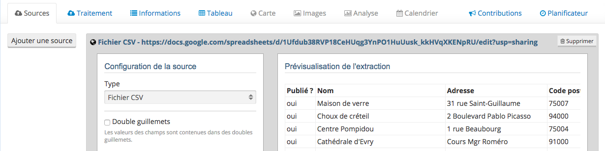
A Google Spreadsheet document will be more than enough to store all data. It also allows for easy collaboration. As a free, instantly available tool, it is by far the easiest way to build a simple database.
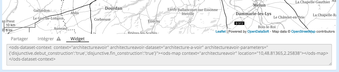
A simple copy/paste is enough to set up this document as a data source for a dataset on the Opendatasoft platform.
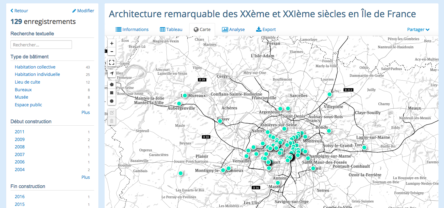
The geolocation processor is then able to place each building on a map.
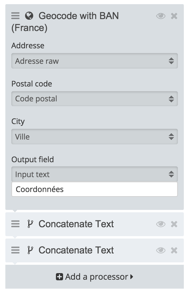
A (free) Mapbox account later, the auto-generated map now uses a custom basemap.
All that is left for us is to copy the HTML code snippet provided by the platform. We now have a fully functional embeddable map, with tooltips support.
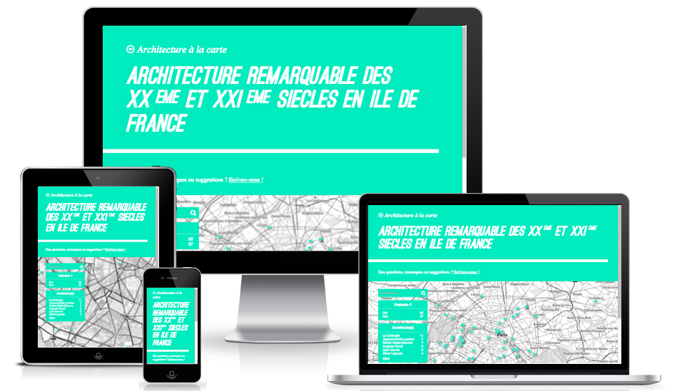
Responsive website
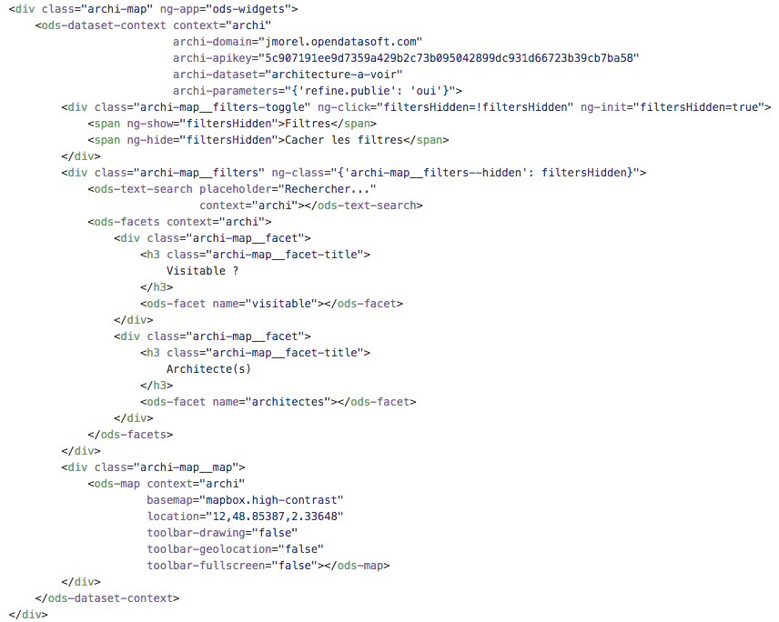
Opendatasoft provides a large open source widget library which allows for easy and quick building of effective dashboards. For our application, we’ll only need the map widget (the snippet we got at the previous step) and filters widgets for data exploration. All of these are already responsive. We therefore only have to embed them within a responsive layout to get an application available with any type of smartphone, tablet or computer.
The website will be built from the 25 lines of codes taken straight from the tutorial. We won’t have to write anything more than pure layout (CSS + HTML) code for our app. No Javascript, no Python, no PHP. All the behaviour is handled by the the widgets. In the end, 120 lines of HTML were enough for the whole website. In other words: nothing. You can have a look at it on its Github repository, all of the code is freely available (under the MIT license).
The application is fully developed, it is only missing a domain name and a server to host its few files. A few clicks later and the application is available at architecturealacarte.fr.
Upcoming improvements
Now that the application is live, the very first task is to make sure that the dataset is maintained, regularly enriched with new buildings, and cleaned from its current mistakes. The Opendatasoft platform has a contribution feature available to registered users, a good starting point. We’ll of course provide an email address for direct contact and should set up a Google Form for new entries.
The second task is also data-related: expand the project to other regions in France. Technically it’d be very easy. A new spreadsheet, a new associated dataset and a copy paste of the current page with the new dataset identifier inside and we’re done. All that is missing are new contributors from all over France!
As a nice final touch, it would be nice to package the website within a mobile app and distribute it through the many app stores.
European Heritage Days and Open Data
The timing is purely random, but at the very same time we’re releasing this website the whole of France’s cultural institutions are gearing up for the European Heritage Days. During 2 days (September 19-20), many (many) buildings will be open to visits, mostly for free. For French people, it’s the only moment during the year they get to visit buildings that are usually closed to the general public (even the most prestigious of them all, the Palais de L’Elysée). The government partnered with OpenAgenda (also one of our partners) to build a very pretty website for this event and released the full underlying dataset through both their own platform and OpenAgenda’s: 25,000+ events, adresses and tours spread all over France. Since this is all open data, we were able to easily import all of the data within the Opendatasoft platform and then needed no more than 15 minutes to duplicate the Île-de-France page on Architecture à la Carte and set it up for this new dataset. 15 minutes to get a minimal, straight to the point website for this two-days event. One of the many advantages of institutions having a clear open data policy.
Final words
It took an hour to set up the dataset on the Opendatasoft platform, a day to design the website and another one to gather the data. All in all, little more than a weekend’s worth of work to build and release an interactive website compatible with any mobile device and fulfilling an unmet need. Pretty nice.

Every year, Opendatasoft employees leave their offices in Nantes, Paris and Boston for an off-site away day. This year, they visited the town of Le Pouliguen in western France and spent an afternoon contributing to the OpenStreetMap project. Find out more in this article.

Enriching your data with external datasets is an essential step to providing complete, high-quality data to users, and helps generate new, value-creating insights. Find out more about the use of external data by our customers to enrich their portals.

What holds back the sharing of geographic data and how can these barriers be overcome? Our blog shares best practice for unlocking greater value from your GIS data by making it part of your wider open data program.
Every year, Opendatasoft employees leave their offices in Nantes, Paris and Boston for an off-site away day. This year, they visited the town of Le Pouliguen in western France and spent an afternoon contributing to the OpenStreetMap project. Find out more in this article.
Enriching your data with external datasets is an essential step to providing complete, high-quality data to users, and helps generate new, value-creating insights. Find out more about the use of external data by our customers to enrich their portals.
What holds back the sharing of geographic data and how can these barriers be overcome? Our blog shares best practice for unlocking greater value from your GIS data by making it part of your wider open data program.