2016 United States Election Results in Open Data
At Opendatasoft, we decided to go ahead and, in the spirit of what we do best, build a map using open data of the United States Presidential and Congressional Election results.

Whether Democrat or Republican, Constitutionalist or Green Party, Libertarian or Independent, the 2016 US Election has come to an end, and it’s time to get to know our new elected officials! At Opendatasoft, we decided to go ahead and, in the spirit of what we do best, build a map using open data of the United States Presidential and Congressional Election results.
An Open Dataset of the 115th Congress
Open data is a powerful tool of Open Government. Therefore, we began by building a dataset containing the Party, District, photo, and link to the website of every member of Congress, both newly elected and incumbent. This now makes it easy to search for a complete list of the US Congress, House and Senate included. It’s also easy to see very precisely what part of the country she or he represents.
You can find the dataset here: United States 115th Congress
But more importantly for democratic participation, links to each member of Congress’ websites provide citizens the resources they need to inform themselves on each Congressman or woman’s position. These sites also provide easy access to the information needed to contact representatives, and engage in the democratic process.
With this open dataset, it’s never been easier to navigate these elected officials with search, filter, mapping, and graphing tools!
Using the Map-builder tool, we then created the map. We used the dataset, and added five layers:
– Democratic Representatives
– Republican Representatives
– Democratic Senators
– Republican Senators
– Independent Senators
To add each layer, we could easily filter the data with just a simple click of the mouse or tap on the touchpad. The data automatically displayed on a map, including the associated SHAPE Files for Congressional Districts.
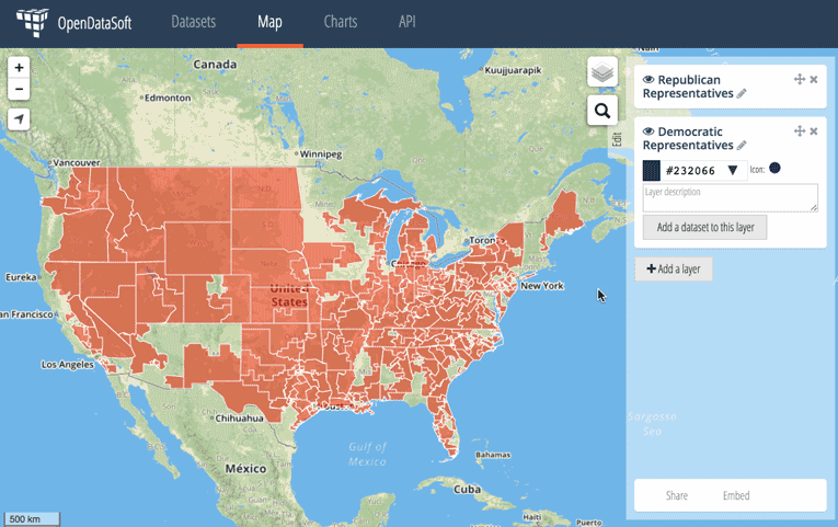
The Cartograph then allowed us to change the colors of each SHAPE so that we could associate them with Republicans, Democrats, or Independents. Each state, as a result, has a different degree of red or blue, depending on if it has a mix of party representation or not.
Post-election days can often be confusing times, as the nation gets ready for administrations, representatives, and senators to begin their shift. It can sometimes be difficult to know who is the representative even in a neighboring district! Nonetheless, being informed is critical to the proper functioning of our open societies. However, with this tool, citizens can discover who represents neighboring districts, who represents far-away districts, and anyone in between.
It can also provide insights into the very demographic layout of the United States, by showing just where concentrations of populations are. This information comes from looking not at colors, but the size of congressional districts in a given state.
We hope that this map, in addition to easy-to-search dataset will help people gain a better understanding of their elected officials at the federal level. This map is easy to share and embed in anywhere on the web – simply copy and paste the URL or iframe, and paste it where you would like it to go!
Presidential Election Results by County
Of course, the Presidential Election got the most attention. You can browse in open data the election results on this map below, county by county. Know how your county voted. Know how your neighbor’s county voted. In the easiest way possible!
You can access this dataset here: USA 2016 Presidential Election by County
Happy exploring!