How Smart City Tech and Open Data Can Help U.S. Mayors Uphold the Paris Climate Accord (Part 3)
This blog post is the third installment of the larger theme "How Smart City Tech and Open Data Can Help U.S. Mayors Uphold Paris Climate Accord". This last part focuses on resilience and adaption, and how open data and smart city technology can help.

Parts 1 and 2 of this series look at U.S. mayors’ commitment to upholding the Paris Agreement through mitigation efforts (primarily greenhouse gas (GHG) reductions) aimed at keeping the global temperature rise this century well below 2C°. In this installment, we consider the U.S. mayors’ efforts to manage the risks of a warming planet through resilience and adaptation, and look at how open data and smart city technology can help.

A Unique Agreement: Adaptation Takes Main Stage
The Paris climate accord was unique in the breadth of its support. It was signed by every nation on earth except for two: one who was in the midst of a civil war (Syria), and another, Nicaragua, who felt the targets were not aggressive enough (nor support for developing nations sufficient).
The Agreement was also distinct from prior climate accords in giving adaption equal emphasis alongside mitigation. It’s an acknowledgement that climate change is already having a serious impact on people, places, and resources, and will continue to do so for a very, very long time even if emissions dropped to zero tomorrow.
The adaptation activities covered by the accord are divided into five categories:
- Observation: Collecting data to better understand and predict climate change impacts
- Assessment: Identifying and evaluating adaptation options
- Planning: Developing implementation plans for selected actions
- Implementation: Executing action plans
- Monitoring & Evaluation: Regularly monitoring, evaluating and revising plans
The risks addressed by these actions include those associated with more frequent and intense storms, extreme heat, longer and more severe droughts, rising sea levels, disease outbreaks, energy and food supply disruptions, population displacements, and more.
Particular Risks for Cities
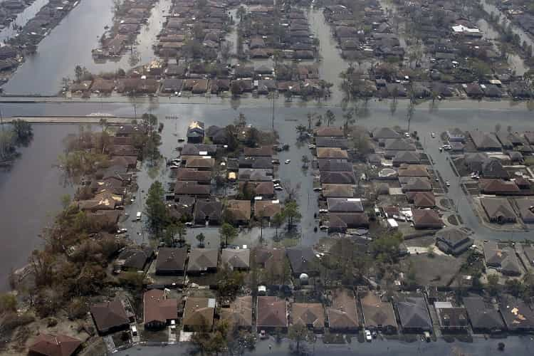
These climate change effects vary greatly in their impact across regions. However, certain among them carry priority risks for a large number of cities. One example is flooding. Inundations due to sea-level rise, storm surges, and heavy rains are already affecting numerous cities.
Flooding
The increased flooding cities are grappling with has caused injuries and deaths, interrupted road traffic, swamped underground transit systems, damaged homes and businesses, and overwhelmed storm drains and sewers. For inundations due to ocean storm surges or tidal flooding, saltwater has also contaminated freshwater resources and killed vegetation. (For a look at the sharp increase in coastal nuisance flooding in recent years, years, see this NYT article. For a look at urban flooding scenarios on the horizon, see this Citylab post.)
Extreme Heat
Many U.S. cities are also coping with an increased number of days of extreme heat and humidity, and this pattern will continue and intensify. This is a serious public health concern. Heat is the leading weather-related killer in the U.S. according to the National Weather Service, and it takes it heaviest toll on the most vulnerable of citizens: children, the elderly, the sick, and the poor. Extreme heat also impacts labor productivity and heightens the risk of blackouts as air conditioning use spikes.
Air Pollution
Intense heat also contributes to another significant urban health risk: air pollution. Elevated heat can cause air to stagnate, exacerbating existing pollution by increasing ground-level ozone and particulate matter. And, heat waves are often accompanied by droughts, leaving cities without the pollution relief of rainfall (and straining municipal water supplies).
Taking Action Begins with open data

Addressing threats like the above begins, as noted in the Paris Agreement, with collecting and openly sharing the observational data scientists need to better understand and predict climate change impacts.
open data has always been at the heart of climate science, with governments, universities, non-governmental and supranational organizations gathering and publishing climate-related open data for many years (see, for example, the work of the World Meteorological Organization (WMO) and WMO co-sponsored observing systems like the Global Climate Observing System, the Global Ocean Observing System and the Global Terrestrial Observing System).
The Paris accord seeks to strengthen this data collection and sharing, and to make the data, and the analyses developed with it, as accessible as possible to those developing national adaptation plans. With the U.S. withdrawing from the Agreement, U.S. mayors and supportive regional and state governments will play an even more important role in gathering and sharing observational data.
Fortunately, this work was already underway before the U.S. withdrawal through organizations like the Global Covenant of Mayors for Climate and Energy. U.S. covenant mayors have pledged themselves to the sharing of open, compatible data to meet the needs of their own cities while contributing to national and global repositories designed to help everyone understand and respond to climate change.
Fortunately, emerging smart city technologies, like Internet of Things sensor networks, are making it easier for cities to collect this data, while extending the range, accuracy and timeliness of the information that can be gathered.
Smart City Technology Can Fill the Data Gap

Environmental data that urban sensors can capture includes air pollution levels, water quality measures, micro-level weather readings, light and vibration measurements, and more. Sensors deployed on infrastructure can monitor conditions such as energy grid load and water system pressure. Sensors affixed to structures like traffic signals and buildings can also capture vehicle and pedestrian flow.
Below are some examples of the ways in which U.S. cities are using sensor networks and open data to identify and respond to their climate change vulnerabilities.
Chicago: An Array of Things
The City of Chicago is deploying a new smart city sensor network on light poles and buildings that is designed to deliver ‘block-by-block’ data sets that it hopes will improve urban design and policy, and support better, more finely-tuned resilience strategies. The project, called the Array of Things, currently comprises a wide variety of environmental and activity sensors, and the city hopes to eventually use the sensor system to examine storm water runoff, urban flooding, and drainage issues. The data will be analyzed and shared through the city’s open data portal, and will no doubt eventually play a role in executing and monitoring adaptation efforts.
Brooklyn Microgrid
Brooklyn has launched a solar-powered microgrid project that uses smart technology and a blockchain framework. Through a peer-to-peer mobile app, Brooklyn Microgrid participants can buy or sell green energy in real-time while benefitting from a local generation and storage network that can function independently even during blackouts.
Because it can keep the power on when storms or heat waves cause wide-area outages, the Brooklyn Microgrid supports NYC adaptation targets, and, because it is solar-powered, it is helping NYC meet its mitigation goals as well.
Microgrids like the one in Brooklyn are expected to play a major role across the U.S. in local and regional resilience efforts as they can address the need to keep critical facilities operational (e.g., police and fire stations and medical facilities). And, as open microgrid data from rolls up into city and regional data portals, it will be of high value in allocating emergency resources in real-time. (See the Institute for Local Self-Reliance’s Energy Democracy Initiative for issues and case studies of U.S. microgrids.)
New York City: A Hurricane Response Blueprint
As Hurricane Sandy approached New York City, government and community technologists collaborated to produce updated evacuation zone maps based on continuously updated flooding projections. The data was fed into the City’s open data portal, enabling developers to create emergency maps and applications.
As it had done during Hurricane Irene, the City also worked with partners to develop a Hurricane Sandy map for New York featuring evacuation zones and routes, NYC food distribution points, Red Cross shelters, NYC evacuation centers, FEMA disaster recovery centers and more. That map used open data from sources including Google, the NYC open data portal and national weather and emergency management services. The response, honed through two hurricanes 14-months apart, has established a blueprint NYC can re-use in responding to future storms.
Miami: Priorities & Alerts for Flooding
Plagued by increasing nuisance flooding, the City of Miami has launched numerous projects to hold back the tide and protect vital resources, including building seawalls, raising streets and installing pumps. To help ensure optimal decision making for such high-cost projects, the City has launched a pilot program that uses open GIS (geographic information systems) data, 3D modeling, waterfront sensors and a light-based radar system (LIDAR) to improve identification and prioritization of flood-prone areas, and to support timely flooding alerts.
Seattle: Hyper-Local Weather Watch
Like Miami, Seattle has flooding challenges, though driven by heavy rainfalls rather than rising tides. To enable the City to be more proactive in protecting its infrastructure from the flash floods these rains can bring, Seattle launched RainWatch. Developed in partnership with the University of Washington, the National Weather Service (NWS), and Seattle’s public utilities, RainWatch uses a sensor network to develop hyper-local weather predictions. It uses rainfall estimates derived from public weather services and calibrates these estimates using real-time data provided by on-the-ground local rain gauge networks. As a result, predictions are more accurate and more localized. This enables city personnel to better identify and respond to potential flooding. Residents can also interact with this data through a mobile and web application for better personal decision-making.
San Diego: Smart LED Lighting
The City of San Diego is adding air, traffic and pedestrian safety monitoring sensors to 14,000 of its street lights as it upgrades them to smart LED lighting. The new monitoring system will have a host of research, planning and operational benefits, including climate change adaptation.
The pollution sensors will be able to pick up highly-localized information on pollution levels that residents can use to adjust their activities as needed when heat-related pollution build ups. The traffic and pedestrian sensors will produce data that can be used to identify and respond to traffic interruptions due to floods and storms. To support use cases like these, the City plans to make the sensor data available in real-time as open data in conjunction with its partner GE Current, enabling the government, city partners and civic technologist to leverage it for analysis and mobile application development.
Challenges Ahead, but the Momentum Is On

With adaptation as with mitigation, cities will face technical and financial hurdles in meeting the U.S. objectives set forth in the Paris Agreement in the absence of federal leadership. The issue is largely the same as the one Sam Brooks made in GreenTechMedia with respect to GHG reductions: there are some important factors that are simply outside of municipal control, even though there is much cities can do, especially when collaborating with one another, and with regional, state governments and international organizations.
The same holds true for adaption, even though Federal Emergency Management Agency, the Environmental Protection Agency, the NWS and other U.S. agencies have been critical partners for cities in adaption planning, and the future level of support from these agencies is uncertain.
Financing, too, will certainly be a challenge. Many adaptation measures are not high-tech, but they are high cost, like building seawalls, raising streets and buildings, and relocating or replacing vulnerable infrastructures.
However, many solutions, like green infrastructure technologies (e.g., permeable pavement, vegetated swales, and green roofs) are feasible, as are many smart city technology solutions. And smart city tech has proven to be effective at helping cities do more, for longer, with their existing assets. Moreover, if at cities provide open access to smart city sensor data, the flow of data and knowledge between them and their residents, and between cities and public and private partners at home and abroad, can without a doubt keep the momentum going.


