What Is a Basemap and How to Choose the Best One for Your Data?

Without a basemap, your geographical data has little value. This blog post walks you through the definition of a basemap and how to choose one for your data platform.

One of the most popular ways to make data accessible to people is to create a map. It is an interactive and intuitive way to integrate data into familiar concepts, whether you want to show locations, highlight evolutions using heatmaps, or display all the cities that voted for a left-wing candidate this year.
However, data on a map are just things drawn in the 2-dimensional air, and they need a canvas to be drawn on (roads, seas, city boundaries…). Why? Because, unfortunately, humans are still very bad at knowing that latitude 48.858333°, longitude 2.294167° is actually the Eiffel Tower (you know, between the patch of grass at 48.832,2.315353 and the river Seine at 48.86123,2.282235).
As such, the canvas itself (or “basemap“) is mandatory, and has the heavy responsibility of supporting your data and providing the geographical context; but many people tend to just go for the first basemap that they come across, and forget about it. It is actually easy to spend a little more time to find the right basemaps for your data, and make your data shine even brighter. Opendatasoft makes it easy for you to integrate specific basemaps for your data.
Giving Context to Your Markers with Basemaps
Currently, apart from a few big players like Google, most of the basemaps you find on the web are built using data from OpenStreetMap, a free project dedicated to gathering enough data to build a highly-detailed map of the entire world. Chances are that your area is already fully available inside OpenStreetMap (browse and see for yourself). This means that depending on the basemap, you could display very detailed information like trees, restaurants and so on. For example, the OpenStreetMap project provides a few very specialized basemaps for transports or cycling paths, and you could use them to highlight very specific datasets:


But you have many choices if you just want to show what people would consider as a “normal map” (which often means “like Google Maps” or “like Apple Plans”), and you’ll probably recognize the following from many maps on the web:

Mapbox Streets

You can also find “special” basemaps, such as the “Pirate” map and the Comics map from Mapbox. To be honest, it is quite hard to use in your everyday life, but you may feel the need to find a reason.

Mapbox Comic

Finally, there is the kind of basemaps where you try to find your house from above – with an aerial or satellite view. This is a bit less common for several reasons. First, it can be expensive when done properly (did you ever wonder why no satellite view had clouds?) and is therefore harder to offer for free. Second, it is very high on contrast and has a lot of different colors, which means that it is hard to display additional data on it while keeping it visible. Even so, providers like Mapbox have made such basemaps available, sometimes with overlays for roads and boundaries.

Mapbox Streets Satellite
Neutral Basemaps for Analytical Data
Maps are not only useful to locate sights, they also provide powerful support for analytic representations. You can represent your city’s districts and color them according to population density, display a heatmap of the number of births in the U.S. after the Superbowl, or you can show your city’s traffic using red and green roads. In these cases, you’re playing with different colors, or a single color gradient. For the sake of clarity, you don’t want to display this on a map with different colors that may interfere with the colors of your analytics. Providers like Mapbox offer “neutral” maps that provide perfect support for these kinds of visualizations.

Mapbox Dark

A lot of maps can benefit from such basemaps, as it would make them tremendously clearer and more explicit.
A Map Canvas Just for You
Sometimes, you want to have a basemap that is yours. Maybe you want a regular map but with your own colors; maybe you want a map that shows certain things and hides others to make it a better support for your data (for example a transport company may want a railroad-centric map to highlight their operational internal data). As basemaps are a well-established standard, there are a few different ways to create your own map, although all of them are a bit technical and require some non-trivial operations.
The easiest way (as far as we know) is Mapbox Studio which takes care of many things like hosting, but still requires you to learn a bit of CartoCSS (“CSS for maps”). There are alternatives offered for free to build your own stack, such as Kosmtik + Tilestache. The point is – these basemaps can be seen as styles applied on top of cartographic data (e.g. from OpenStreetMap), and can be done by anyone with a some technical skills and enough time.
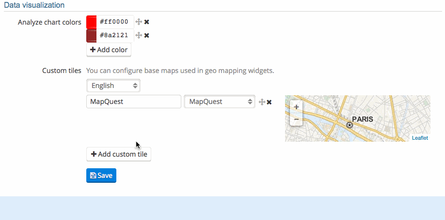
Basemaps in Opendatasoft
If you are an Opendatasoft customer, you know that it is easy to configure one or more basemaps for your data. In your Domain page, you’ll find a place to add and edit your basemaps: by default, you can choose between a few free basemaps; you can create a Mapbox account to benefit from the Mapbox integration and add their 14 basemaps to that choice. You can also configure your own basemap if you have the URL, or even a WMS service; just don’t forget to add attribution if the basemap requires it.

Dashboards, data stories, interactive maps… There are many types of data visualizations (or dataviz). In this article, we outline the different types of data visualization, understand who they are for, and how to choose and use them to their full potential.


This week, OpenDataSoft has cooked something special. After studying the Council of Paris, French trains' Open Data, Gender Equality in Europe and the state of Open Data in 2014, OpenDataSoft continues its Open Data Weekly series to show you how to create a map with Open Data. Au menu: the ultimate map of French Cheese, all in Open Data. Grab a piece of baguette and read on!
Dashboards, data stories, interactive maps… There are many types of data visualizations (or dataviz). In this article, we outline the different types of data visualization, understand who they are for, and how to choose and use them to their full potential.
This week, OpenDataSoft has cooked something special. After studying the Council of Paris, French trains' Open Data, Gender Equality in Europe and the state of Open Data in 2014, OpenDataSoft continues its Open Data Weekly series to show you how to create a map with Open Data. Au menu: the ultimate map of French Cheese, all in Open Data. Grab a piece of baguette and read on!